Monday, January 17, 2011

Snow Pause


County booking totals for the first 11 days of 2011 color coded by arresting agency. (Source: Hamilton County Sheriff's Office.)

Friday, December 10, 2010

Here Goes the Neighborhood

The announcement that the Chattanooga Police Dept and the Hamilton County Sheriff have started using CrimeReports.com is good news. If you haven't read the articles with info from the press release then read them first for some context - Chattarati and TFP reported it. This provides a great tool for citizens and Neighborhood Associations to see what incidents are happening around them and to be able to do some basic analysis when paired with other tools. So, I will use the CrimeReports site as a point of departure to explore a handful of these online tools available to us in Chattanooga and Hamilton County. These tools, combined with neighborly communication, should help people understand more about the public safety issues surrounding them. So, for the first installment, lets look at how to use CrimeReports.

CrimeReports provides departments with a way to share their incident reports with citizens through an easy to use map interface. It appears to be a Flash wrapper around a Google Map rendered through the Google Maps API from the incident file.

To use the site, simply type in a location in the My address field and click Search. (You can just put in Chattanooga if you don't wont your address added to their database.) In addition to crime incidents, it also provides detailed information on registered sex offenders, including their address and for many a photograph and physical description. Careful with that data, there is a disclaimer you have to agree to when using it. If you are just looking for crime incidents, you can toggle the sex offender layer off. (This data layer seems to come from an API call to the state registry.)

Now that you have defined the area you want to look at, you just have to pick the time frame you want to see and the crime types from the Map Tools bar in the upper right of the screen. You have a choice of 3,7,14 and 30 days for the quick links, or a custom time frame from the calendar. CrimeReports is going to show you a moving window of 6 months, so if you think you will want to see data from June 10th sometime in the future, you would want to capture that data today. The Crime Types pop up allows you to select up to 30 incident classifications. Once selected and applied, you get a map showing those incidents in the time frame chosen.


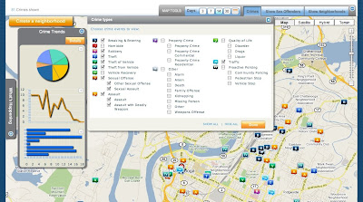
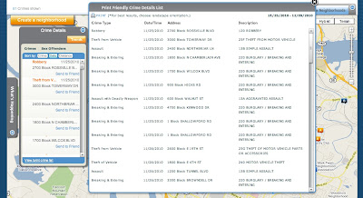
Exploring your map is fairly intuitive, you click on an incident icon and get a pop up that gives you the date, block location, police report number(?), time, UCR classification, and reporting agency. You can also email the incident to a friend from the pop up. One of the best features is the Crime Details toolbar on the left side of the screen. From there you can get a list of incidents by crime, date, and distance. Click on the Trends button and you get can get your graph on. Click on a graph to enlarge it. Click back on the Details button and look at the bottom of the window, you can print a list of all incidents in your filter. Very nice. Unfortunately, it isn't easy to copy and paste that info out because it is a Flash pop up. I even printed it to pdf and couldn't extract it because it is an image, oh well.


There is also a neighborhood feature pending, click on Create a Neighborhood to see the status message. This could be an interesting feature, but I can see how it would be impossible to control.

Nice tool, easy to use, and now that you know how it works, you should get the free CrimeReports iPhone app! It is a very nice app that can, of course, use your current location and show incidents reported near your location. If you create an account with the site, you can even setup alerts for reports. Of course, these alerts will only fire when the file containing the incident is uploaded, so the alert could be 3 days old when you get it, but it is still a very nice feature.

So now you have looked at all the incidents reported around you and seen trends over 6 months... now what?
If you are interested in the trends for these crimes in an area, you can always hit up the SOCRR Public safety report from the Ochs Center. For incident counts and trends over 5 years, choose a neighborhood and play with the Tableau Public interface, I also posted one a while back.

If you are interested in gaining insight into a particular incident or series of incidents, then you need some more tools to use along with the map. I will outline some of these in upcoming posts. A hint to what is next... you noticed that the data CrimeReports gives you only provides a block location and not an address of the incident. Well, and I may be making some assumptions here, the Google Maps API isn't going to map with any level of acceptable accuracy a block location. It needs something like an address. If you zoomed in on any incidents, they are sitting on top of a parcel. Oh yeah...

Friday, November 19, 2010

Catch Up

Ok, been a while... and a lot has happened.

On the Ochs Center's SOCCR front, the Health report has been released and the Economic one is soon to follow.

Tableau Software released version 6 with some nice new features.

I have started playing around with Google Refine. It is a Google release of a previous Freebase app used for cleaning up messy data. To give it a try, I have been using it to clean and prep the NUFORC database that I got from InfoChimps. It is a really nice tool. It works very well for things that would take function writing in Excel or cursors in mySql. It certainly doesn't replace those two, but works very well with and between them.

Oh yes, UFO data. This is the most distracting data I have ever worked with because I want to read every entry. There are over 60,000 entries in the set, I extracted the 870+ ones for Tennessee and further broke it down to the Chattanooga area. I hope to have time to work on extracting the ones for the US, but it is a little messy....that's where Refine is helping. Here is a preview of some info. This graphs the reported shapes, or lack thereof, of the craft. (Note: this is TN only).

Friday, September 3, 2010

2010 SOCRR Public Safety

In case you missed it, the Ochs Center for Metropolitan Studies released the public safety part of its 2010 State of the Chattanooga Region Report (SOCRR) a few weeks ago. You can, and should, download the full report. However, there is a very nice new feature on the site that uses Tableau to display, and allow interaction with, the report data.(North Chattanooga example) Below is a version of it with side by side viewing of crime rate changes by percent and number of incidents. This one works ok to about 3 or 4 comparisons, but with all of the years of incident totals you have to scroll a bit. I did this to demonstrate the fact that you, yes you, can download this data and do something with it. Two things about this - Why this is important and how you can use it.

Is Important - Having these interactive worksheets on the Ochs Center's site is important for many reasons. The ability to interact and do comparisons between neighborhoods is done in an intuitive way that simply wasn't possible before. This tool is great for individuals, organizations, and neighborhood associations who, in the past, had to dig through the full SOCRR or compare individual pdf files for the neighborhoods. Now you just click to build the info you want to see, maybe do some tweaks and then you can save an image or pdf of the chart to use in a presentation. Better yet, you can view the data and download it. If you really need to spend some time with it, download the whole workbook and explore it, full screen, on your computer with the free Tableau Reader. (When using the site, pay attention to the icons on the bottom of the viz, they are what allow you do these things.) This tool, together with the full SOCRR, is a strong combination. The tool allows for quick reference and numbers, but without understanding the data sources and report methodology outlined in the full report, it is just looking at the surface.

Use It -
Apart from doing quick comparisons here or at the source, there are more fun and powerful things you can do with it. As mentioned, you can download the whole workbook from the download link in the lower corner of the viz. This workbook can be opened in any Tableau product and explored or, in Desktop and Public, manipulated and transformed. For example, if you just want to explore the charts full screen, you can use Tableau Reader. It gives you basic functionality but doesn't allow any changes to the data or workbook. If you wanted to dig deeper and alter it to your needs, you could use Tableau Desktop or Tableau Public(free). (Note - anything saved in the Public version is published to Tableau's servers and is available to be downloaded by anyone. Thats how you got it!) With the one below, I took the workbook, cut it down to a few sheets and created a dashboard and placed them side by side. Another one I am working on triggers the charts from the shooting map I built. So you click on an incident and it displays crime stats for that neighborhood. Likewise, I will try to set a filter on the neighborhood list so choosing a neighborhood will highlight the incidents on the map. You get the idea. Keep an eye out as the rest of the SOCRR is rolled out.


(Another note: Not that it would change things here, but I am now on the board at the Ochs Center. I don't have any connection to Tableau, I just love and use their products.)

Wednesday, August 18, 2010

Transparency and Scrutiny

Something I have been thinking a lot about this year is the role of support and scrutiny in respect to transparency. I would guess that in many places resistance to a broader transparency in government is rooted in an aversion to, or fear of, scrutiny. On the opposite end, we would have proponents of transparency with an interest in using the open data and information to support their cause or interest. What is the difference? If my cause is to scrutinize a particular public figure, then I seek information and data to support that. Or if I am supporting a particular candidate, I would be interested in information that would support them and their claims. Etc. Etc. I think the two intentions, support and scrutiny, are, in the case of civic participation, inseparable parts of a whole. For now, I think the tone of this interplay is set by the initial intention. If one sets out to "hold feet to fire", then they will be on a mission to scrutinize. Perhaps the counterpart to this, as support, would be "keeping one's head in the light".

This relationship will continue to be in my thoughts as I hope it reaches a point of maturity. However, in light of the past few weeks in Chattanooga, I thought it was apropos to discuss with a recent transparency discussion at the County Commission and an active effort to recall the mayor and some council members.

Contentious times in the Scenic City. Not yet time to quote Schiller, but Lincoln out of context....

"I am loath to close. We are not enemies, but friends. We must not be enemies. Though passion may have strained it must not break our bonds of affection. The mystic chords of memory, stretching from every battlefield and patriot grave to every living heart and hearthstone all over this broad land, will yet swell the chorus of the Union, when again touched, as surely they will be, by the better angels of our nature."


Thursday, July 1, 2010

Shootings by Day/Council District


This graphic is one of several that are taking shape from the shooting data. I am taking the different descriptive dimensions in the dataset and combining them to see what is there. Other dimensions include school zone, school district, neighborhood (defined using the neighborhood map from the Ochs Center), and day and time of incident. While a lot of these pieces aren't a surprise, it is interesting to look at them in new ways. For instance, I would not have guessed that, for this year, Tuesdays would be a big day for shootings second to Saturday (11 and 13 respectively). In District 8, Tuesday beats Saturday 7 to 2. Below are the District 8 incidents on the map coded by day.


Thursday, June 24, 2010

Stand Response Distribution recap


Since it is being discussed today, here is a repost of the map showing response areas of Stand.

Followers